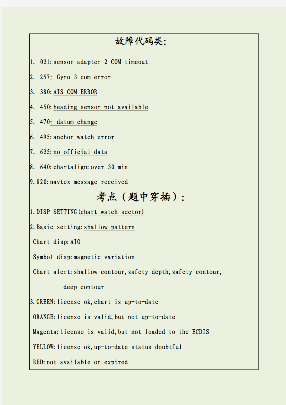

故障代码类:
1.031:sensor adapter2COM timeout
2.257:Gyro3com error
3.380:AIS COM ERROR
4.450:heading sensor not available
5.470:datum change
6.495:anchor watch error
7.635:no official data
8.640:chartalign:over30min
9.820:navtex message received
考点(题中穿插):
1.DISP SETTING(chart watch sector)
2.Basic setting:shallow pattern
Chart disp:AIO
Symbol disp:magnetic variation
Chart alert:shallow contour,safety depth,safety contour, deep contour
3.GREEN:license ok,chart is up-to-date
ORANGE:license is valid,but not up-to-date
Magenta:license is valid,but not loaded to the ECDIS YELLOW:license ok,up-to-date status doubtful
RED:not available or expired
BLUE:canceled chart
单选题(目前72个,未完待续)
1.how do you get information on an ENC object(buoy-beacon-berth etc)on the FURUNO ECDIS?
A.I right click on the use chart function in the route planning tool.
B.I click on the chart info in the instant access bat
C.I enter click on the object.
D.I right click on the object
估计答案:D
正确答案:
2.where can you find a list of the manual updates that have been applied to the FURUNO ECDIS?
A.in the chart legend
B.In the manual update window
C.In the chart catalogue
D.In the chart display menu
估计答案:B
正确答案:
3.how can you see if a chart object i cteated using manual updates?
A.the manual update will be larger than any other chart objects
B.It is always shown in red
C.It will have a special orange marker
D.There is no way i can see if a chart object is created using manual updates
估计答案:C
正确答案:
4.How do you add navigation chart objects to the FURUNO ECDIS when you are require to do so by notices to mariners?
A.i can not add any chart objects to the ECDIS unless they are included in the weekly update
B.I use the manual update function
C.I use the user chart function
D.I use the chart edit function
估计答案:我估计选B老大选D
正确答案:
5.how can you verity which route is being monitored?
A.by clicking on the“route”and then on“route info”in the quick access sidebar in Plan mode
B.The mame of the route will be displayed in the status bar
C.By clicking on“route”and then on“route info”in the quick access sidebar in Navi mode
D.I can not get information on the route which is being monitored
估计答案:C
正确答案:C
6.where do you switch between multicolor and two color setting for the chart?
A.in chart legend
B.In symbol display
C.In basic setting
D.In chart display
估计答案:C网上选C
正确答案:C
7.what should you remember to set up first when planning a route?
A.the setting for the voyage log
B.The alarm level in the operation submenu
C.The safety contour in the route planing tool
D.The radar overlay
估计答案:C
正确答案:C
8.Which ECDIS setting is adjusted in ship and route parameters?
A.chart alignment排列图
B.Safety contour
C.Safety depth
估计答案:C
正确答案:C
9.When do you use a manual update?
A.always when i have to update my charts
B.When i receive information which must be displayed on my ECDIS and this is not yet included in the official weekly updates
C.I should never use manual updates
D.When i have to update the software of the ECDIS
估计答案:B
正确答案:
10.How do you hide(not delete)a manual update objetc?
A.i select clear from the manual update menu
B.I select undo last from the manual update menu
C.I deselect that general type of chart object in the chart display dialogue
D.I deselect the option from the symbol display dialogue
估计答案:A
正确答案:
11.Can you create a manual update from an AIS safety message shown on the ECDIS?
A.yes-by manually creating the object
B.Yes-by letting the ECDIS creat the object antomatically
C.Yes-either by creating it manually or letting the ECDIS create it automatically
D.No
估计答案:A
正确答案:
12.which recording function is available in the FURUNO ECDIS?
A.gyro log
B.Engine log
C.Ship’s log
D.Details log
估计答案:D
正确答案:D
13.How do you update your vector charts on the FURUNO ECDIS using the ENC update CD?
A.i use the autoload function
B.I cteate a manual update from the information on the CD
C.I creat a user chart
D.I import the information using the chart details function in the chart catalogue
估计答案:A
正确答案:
14.can you edit the user chart when the ECDIS is in Navi mode?
A.Yes
B.Only if the user chart is not linked to a route plan
C.Yes if the user chart contains no tidal information
D.No
估计答案:D
正确答案:
15.Can you edit a route without removing it from the route monitoring function?
A.No
B.Yes,but i must copy it to another ECDIS where it can be edited without interfering with the monitoring function of the FURUNO ECDIS
C.Yes,if i create a copy of the route plan in ANTS format on a USB and edit the file on a normal offrice PC
D.Yes,if i select copy from monitor in the route plan menu and edit the copy.when copying is completed i select-exchange with monitor in the plan menu
估计答案:D
正确答案:
16.Which operation can you perform on the FURUNO ECDIS?
A.i can record my position manually on the ENCS
B.I can set the ECDIS to automatically shoosing a safety contour based on my setting of ship’s maximum draft
C.I can set ship’s maximum height to enable chart alerts from areas in charts where there is not sufficient air draft
D.I can send a copy of my route plan to an AIS target as a safety message 估计答案:C
正确答案:
17.which informatin can you find in VECTOR CHART LEGEND?
A.T&P notice
https://www.doczj.com/doc/3112718461.html,
C.Warning
D.Safety contour setting
估计答案:B
正确答案:B
18.Where do you select the color Palette(颜色暗淡模式)used to display the charts?
A.in chart legend
B.In chart display
C.In quick accessor bar
D.In chart catalogue
估计答案:C网上选C
正确答案:C
19.Which information can you find in the Raster Chart Legend?
A.horizontal datum
B.Safety depth
https://www.doczj.com/doc/3112718461.html,er permit number
D.License number
估计答案:A
正确答案:A
20.Which information can you find in the Raster Chart Legend?
A.shallow water
B.Chart name
C.Chart viewing date
D.Depth contour
估计答案:B
正确答案:B
21.Which information can you find in the Vector Chart Legend?
A.notice to mariner
B.Presentation library edition number
C.Chart edition&update date
D.Safety contour setting
估计答案:C
正确答案:C
22.How can you tell if your FURUNO ECDIS is displaying an ENC?
A.there is an”ENC data available”indication in the own ship functions box
B.there is an”RNC data”indication in the own ship functions box
C.The FURUNO ECDIS will give an audible alarm if i am not viewing an ENC
D.There is no special indication in the own ship functions box
估计答案:A网上选D
正确答案:
23.How do you manually record Own Ship's current position in the Logs?
A.by opening the voyage log and entering the current position
B.By right clicking on own ship icon on the use interface
C.By press the record button on the control unit
D.By using the record position event function of the event log
估计答案:D
正确答案:
24.What is a Manual Update?
A.A manual update is an update applied using the manual function in load &update charts
B.A manual update is an update to the charts created by the operator from information received from pilot-a navtex message-a VHF broadcast etc.
C.A manual update is an update to the charts by an official representative of the chart producer
D.A manual update is a chart created using the digitizer function of FURUNO ECDIS
估计答案:B
正确答案:
25.What should you do if you have to leave your planned route during
a voyage?
A.switch off the FURUNO ECDIS and concentrate on the radar
B.Disable the routing monitoring on the RURUNO ECDIS
C.Change the display of the FURUNO ECDIS to all IMO all other
D.Configue and enable the check area function to assis me in scaning the ENCS for danger to navigation and hazardous objects
估计答案:D
正确答案:
26.Which operation can you perform(进行)on the FURUNO ECDIS?
A.I can record target ship’s position in the voyage log automatically
B.I can record a position fix manually bu using just one distance and one bearing
C.I can playback my past voyage track on the charts
D.I can send my route plan and user chart and notes to FURUNO GPS for displaying the GPS
估计答案:C
正确答案:
27.Where can you change the settings for the Safety Contour used for monitoring?
A.nowhere-because i must never change the setting for the safety contour
B.In the setting menu and i can only change the setting if i have the service password
C.In chart alert
D.In the route planing tool
估计答案:C
正确答案:
28.Which color scheme is used for a Manual update on the Furuno ECDIS?
A.blue ENC symbols
B.standard ENC symbols
C.orange ENC symbols
D.red ENC symbols
估计答案:C
正确答案:
29.Which setting can be changed in Sensors?
A.log stabilization mode
B.Safety contour setting
C.Safety depth setting
D.Kalmen filter setting
估计答案:A
正确答案:A
30.Where do you change the Ship Outlines(轮廓)?
A.in the quick access bar
B.In chart display
C.In symbol display
D.In the status bar
估计答案:C
正确答案:C
31.Can you set the overall maximum speed for a route plan?
A.yes in the ship and route parameters of menu
B.In chart display
C.Yes in optimization parameters
D.Yes in the route planing tool
正确答案:A
32.Which information can you find in the Vector Chart Legend?
A.magtinec variation
B.Base CD number
C.Permit expiration date
D.Safety contour setting
估计答案:A
正确答案:
33.Where do you change the Velocity Vectors style?
A.in the quick access bar
B.In chart display
C.In symbol display
D.In the status bar
估计答案:C
正确答案:C
34.Where can you find information concerning the charts stored on the HDD(硬盘驱动器)?
A.on the internet
B.The chief officer will know
C.In the chart catalogue
D.In the chart display menu
估计答案:C或D(可能性比较大)网上选C
35.How do you document(记录)your previous voyage on the FURUNO ECDIS?
A.I use my paper logbook as documentation
B.I use my paper logbook and my VDR or SVDR as documentation
C.I use the tracking function in the symbol display
D.I show a playback of my past voyage track on the charts
估计答案:D
正确答案:
36.Which operation can you perform during a voyage or after completion of a voyage?
A.i can use the record function to record special events in the voyage log
B.I can create and save a screen shot(截屏)for future reference
C.I can view and print a copy of details log
D.I can connect the ECDIS to the internat and upload all documentation to an external storage
估计答案:A
正确答案:
37.Which information can you find in the Raster Chart Legend?
A.magnetic variation
B.Safety contour setting
C.Quality of data
D.T&P notice
正确答案:A
38.How can you reset the odometer?
A.I can reset the odometer from the voyage tab of the menu
B.I can reset the odometer from the sensor setting dialogue
C.I can reset the odometer from the symbol display dialogue
D.I can reset the odometer from the quick access sidebar
估计答案:A
正确答案:A
39.Can you plan a route while you monitor another route?
A.No
B.Yes but only if i have two ECDIS
C.Yes the routing planing function is independent(不相关联的)from the route monitoring function
D.Yes but i must select the safety contour for both route plan
估计答案:C
正确答案:C
40.Where do you find information on the software version of the FURUNO ECDIS?
A.in the voyage log
B.In the system dialogue of the menu
C.In the about dialogue
D.In the S52presentation library(图书馆)
正确答案:C
41.How are loaded ENCs converted into SENCs when updating?
A.the FURUNO ECDIS will normally convert(转变)the ENCs to SENCs automatically
B.I must use the conversion tool(转变工具)from the menu
C.I can not convert the ENCs to SENCs
D.I load the new permit file using the file named ENC.PMT and then i use S52presentation library from the system menu in the chart menu to convert the ENCs to SENCs
估计答案:D
正确答案:
42.How do you add navigational chart objects to the FURUNO ECDIS when you are required to do so by information received via VHF broadcast?
A.I can not add any chart objects to the ECDIS unless they are included in the weekly update CD
B.I use the manual update function
C.I use the user chart function
D.I use the chart edit function
估计答案:B(类似于第4题)
正确答案:
43.How do you switch from Vector chart to Raster chart on the FURUNO ECDIS?
A.i select rather chart in the main menu
B.I selet RNC in the chart legend
C.I lelect raster chart from the drop down list in the status bar
D.I selet RNC in the chart catalogue
估计答案:C
正确答案:C
44.Which operation can you perform after completion of a voyage?
A.i can add additional records of manual positions to the voyage log adding further details to the past voyage
B.I can cteate a user chart from the monitored route plan and save it to a USB memory device
C.I can create a backup copy of the voyage plan on a USB memory device
D.I can view and print a copy of the chart usage log(chart alert)
估计答案:D
正确答案:D
45.What is the maximum limit of the Check Area?
A.NO limit
B.240min+20nm+5km+999m
C.120min+10nm+3km+500m
D.999min+999nm+999km+999m
估计答案:B
正确答案:B
46.Which ECDIS setting is activated in Ship and Route Parameters?
A.Gyro error
B.Safety contour
C.Notes alarm time
D.Ship’s minimum speed
估计答案:A
正确答案:A
47.Where do you offset own ship chart position on the FURUNO ECDIS?
A.in symbol display
B.In chart display
C.In chart menu
D.In own ship functions box
估计答案:D
正确答案:D
48.Where do you set system priority of multiple GPS connected to the FURUNO ECDIS?
A.In the sensor dialogue
B.In basic setting.
C.In ship and route parameters
D.In nav tools
估计答案:A
正确答案:A
49.Where do you change the Targets color?
A.in the quick access bar
B.In chart display
C.In symbol dispaly
D.In the status bar
估计答案:C
正确答案:C
50.Where do you control the settings and visibility of the chart layers?
A.in chart legend
B.In symbol display
C.In chart display
D.In basic setting
估计答案:C网上选C
正确答案:
51.which manual update objects can be hidden from view by operatior selecrion?
A.only the manual updates special area(from the chart display dialogue)
B.All manual updates objects(from the chart display dialogue)
C.Only the manual updates buoys(from the chart display dialogue)
D.Only the manual updates sonding(from the chart display dialogue)估计答案:B
正确答案:
52.how do you switch the kalman filter on or off?
A.the kalman filter is always switched on when a route is put into monitor mode and switched off when theres is no route being monitored
B.The kalman filter is always on so i never have to switch it on or off
C.The kalman filter is swiched on or off in the sensor menu on the position tab
D.The kalman filter is switched on when steering is switched to autopilot 估计答案:D
正确答案:
53.when the software of the FURUNO ECDIS is being updated-it is important that?
A.the software is updated by a FURUNO service engineer(古野检修师)
B.the software is updated by the captain(船长)
C.the software is updated by the ship’s electrical engineer(老电)
D.the software is updated by an IMO resentative(IMO组织)
估计答案:A(说明书中指出只能是人而不是单位组织,排除法)
正确答案:
54.which operation can you perform with the FURUNO ECDIS?
A.i can send my route plan and user chart to any RADAR for display on the RADAR
B.i can send my route plan and user chart to any AIS for display on the AIS
C.i can send my route plan and user chart to any GPS for display on the GPS
D.i can send my route plan and user chart to a FURUNO RADAR for dispaly on the RADAR
苏北运河船舶过闸管理办法 (征求意见稿) 第一章总则 第一条为了加强苏北运河船舶过闸管理,规范船舶过 闸行为,提高船闸运行效率,保障船舶安全、有序、快捷地通过船闸,根据《江苏省航道管理条例》、交通运输部《船闸管理办法》等法规、规章的规定,结合苏北运河船闸实际,制定本 办法。 第二条苏北运河解台至施桥十个梯级船闸的船舶过闸 及其监督管理适用本办法。 第三条省交通运输主管部门主管苏北运河船舶过闸的 管理工作。省交通运输主管部门所属的航道管理机构及其船 闸管理单位(以下简称“苏北运河航道管理机构”)具体负责苏 北运河船闸的运行、养护、保护和管理工作。 有关海事管理机构依据职责,负责苏北运河通航秩序管理,配合航道管理机构做好船舶过闸管理工作。 第四条苏北运河航道管理机构应当按照有关技术规范、操作规程和运行制度,科学调度、依法管理苏北运河船闸,为 船舶提供安全、及时、方便的通过条件。 第五条苏北运河航道管理机构和苏北运河沿线海事管 理机构应当建立健全苏北运河水上交通安全和船舶过闸应急
预案,落实工作责任,保障航道安全畅通。 第二章一般规定 第六条通过苏北运河的船舶(以下简称“过闸船舶”)应 当按照国家有关规定标明船名、船籍港、载重线等标志,随船携带《船舶检验证书》、《船舶签证簿》等合法有效的船舶证书,方便船闸登记、调度以及过闸确认。 第七条符合下列尺度的船舶可以正常通过苏北运河船闸: (一)货轮总长68米以下、总宽15.8米以下; (二)拖带船队总长440米以下、总宽10.8米以下; (三)顶推船队总长220米以下、总宽15.8米以下; (四)船舶吃水3.6米以下。 第八条船舶有下列情形之一的,禁止通过苏北运河船闸: (一)货轮总长超过90米或者总宽超过15.8米; (二)拖带船队总长超过440米或者总宽超过15.8米; (三)顶推船队总长超过220米或者总宽超过15.8米; (四)船舶吃水超过3.6米; (五)船舶无标志或者标志不能识别。 第九条总长超过68米但在90米以下的货轮,以及驳
AWENA-1型船载电子海图系统(ECS) AWENA-1船载型电子海图系统(ECS)(前生AWENA-1船舶智能导航仪)是电子航行参考图显示系统(IHO S-57)和船舶智能避碰系统综合应用开发具有完全知识产权的新型船舶助导航产品,符合中国海事局《国内航行船舶船载电子海图系统(ECS)功能、性能和测试要求(暂行)》中的A级设备要求。能有效改善船舶航行的安全性,自动判别周围船舶的多种航行信息,结合电子航行参考图显示系统,实现了航行信息综合显示和智能辅助导航。 ?产品特点: 1. 本机采用模块化设计,以电子海图系统(ECS)为基本显示平台,与各导航传感器的合适组合构成了一套完整的,精确的,综合定位系统,并提供先进的,便捷的最佳化定位功能,有利于安全航行,触摸式的系统操作,更人性化。 2. 具有完全的自主知识产权全中文电子航行参考图显示平台,以S-52标准进行显示国际标准(IHO S-57)的电子海图,具有航线设计功能,并可在图上设置本船安全等深浅和安全水深,并突出显示。 3. 系统可接收处理AIS、GPS、罗经、测深仪、计程仪等设备的输入信息,给出与本船航行有关的周围动态交通状况显示,在航路监视同时,综合分析发生各类碰撞、搁浅、误入禁止区等危险的可能,提前警告,并试验解决途径,提供驾驶员安全规避的操作方案。 4.报警功能:监视各种航行危险并智能计算周围船舶的航行信息,为
船舶提示最危险的航行船舶:到达(接近)转向点指标,超出航迹偏移极限,越过安全等深浅,搁浅危险,接近孤立危险物,接近禁止区域,定位传感器故障等,都会报警。CPA/TCPA计算及报警(声光报警)。 5. 航迹记录:系统记录最近本船12小时内每分钟的实际航迹,可保 存最近3个月的本船实际航迹的独立航行记录。 6、提供国家海事局官方出版的电子海图预安装服务,同时也提供国 家海事局官方提供的电子海图升级安装服务(服务收费)。国家海事局官方出版的电子海图包含国内沿海和长江电子海图数据.海图信息包含的海图版本号,生产日期和套数号码,每套海图数据只能安装该条船只,船检也将对应船只进行相关信息的检查。 7提供用户、上海海事局航海图书印制中心和上海埃威航空电子有限公司三方共同签订提供电子海图数据的相关协议.上海埃威航空电子有限公司将签订的相关信息提供给国家海事局海图出版中心备案。 8. 在签订电子海图预安装服务(服务费1000元)和三方协议后,海 埃威航空电子有限公司将预先安装国家海事局官方出版的电子海图包含国内沿海和长江电子海图数据.用户可以在中国海事电子海图发行网站注册登记网址为(.10/chart),并可获得用户名\密码,免费下载相关的海图更新数据.同时也可以选择由上海埃威航空电子有限公司提供的一季度一次的海图数据升级光盘服务(有偿),保证相关海图数据产品源于官方正规渠道。
致读者的一封信: 亲爱的读者,当您看到这个内容的时候,表示您已进入了知识的世界,非常感谢您付出宝贵的时间对我们的文章进行阅读。我们从小就明白:知识就是力量;知识成就未来,知识可以开拓您的思维,知识可以让您打开眼界;愿所有人都可以在知识的海洋里畅游,在知识的世界里翻滚;知识文库:知识的力量Tel:将为您提供最专业最全面的学习资料,助您快速成长。您的支持就是我们最大的动力;感谢大家动动鼠标点击关注! PS:以上内容下载后,直接删除即可! 所有内容下载后可可以自行去除页眉页脚,处理方法如下: 如您使用的是word: 页眉清除方法: 页脚清除方法: 如您使用的是wps: 页眉清除方法: 页脚清除方法: 最后再次感谢大家;欢迎大家下载全文使用。
测绘百科▏电子海图系统和海图数学基础 dianzi haitu xitong 电子海图系统(electronic chart system)由数据、软件和电子设备构成的显示海图信息的系统。舰船导航和指挥自动化系统的组成部分。用于存储、检索、显示和更新海图信息,叠加实时船位或其他运动目标,辅助航行和海图作业。又指电子计算机可识别、处理,且附于一定载体上的数字形式的海图数据。 主要由四部分组成,计算机处理器、软件和网络分系统,用于信息处理和传输;图形显示分系统,用于显示海图和附加信息;海图数据库,用于管理、产生和维护海图数据;用户接口,用于实施操作和连接导航设备、绘图仪和打印机等。 系统的基本功能有:①海图显示。根据本船位置自动选择和显示现有纸质海图的内容,以及根据需要增加的军事数据层,实现图形放大与缩小、海图投影转换、图形方向变化等灵活显示,符号颜色及其亮度调整等。②计算作业。人机交互实施计划航线标绘、实际船位与航线显示、各种航行参数管理、航路监测、方位距离标示和动态目标监测等。③信息输入输出。可设置数据叠加层,如雷达图像、声呐图像、多波束测深的格网数据、随潮汐变化的深度、运动的海流及其他数据,回放或打印历史航行记录,如时间、位置与速度,海图使用情况。④报警。在设定的状态下,如偏离计划航线、进入禁区、超越安
单选题(目前72个,未完待续) 1.how do you get information on an ENC object(buoy-beacon-berth etc)on the FURUNO ECDIS? A.I right click on the use chart function in the route planning tool. B.I click on the chart info in the instant access bat C.I enter click on the object. D.I right click on the object 估计答案:D 正确答案: 2.where can you find a list of the manual updates that have been applied to the FURUNO ECDIS? A.in the chart legend
B.In the manual update window C.In the chart catalogue D.In the chart display menu 估计答案:B 正确答案: 3.how can you see if a chart object i cteated using manual updates? A.the manual update will be larger than any other chart objects B.It is always shown in red C.It will have a special orange marker D.There is no way i can see if a chart object is created using manual updates 估计答案:C 正确答案: 4.How do you add navigation chart objects to the FURUNO ECDIS when you are require to do so by notices to mariners? A.i can not add any chart objects to the ECDIS unless they are included in the weekly update B.I use the manual update function C.I use the user chart function
1. Which operation can you perform on the FURUNO ECDIS? ( B ) a. I can play back my ship’s past track on the ECDIS b. I can record my position manually on the RNCs. c. I can create Notes from my Voyage Log to document a voyage on the charts. d. I can set the ECDIS to include engine log information into the Voyage Log automatically. 2. Which operation can you perform on the FURUNO ECDIS? ( A ) a. I can record my position manually on the ENCs. b. I can set the ECDIS to automatically choosing a Safety contour based on my setting of ship’s maximum draft. c. I can set Ship’s maximum height to enable chart alerts from areas in the charts where there is not sufficient air draft. d. I can send a copy of my Route Plan to an AIS target as a Safety Messag e. 3. Which operation can you perform on the FURUNO ECDIS? ( C ) a. I can record target ship’s position in the Voyage log automatically. b. I can record a position fix manually by using just one distance and one bearing. c. I can playback my past voyage track on the charts. d. I can send my Route Plan and User Chart to a FURUNO GPS for display on the GPS. 4. Which operation can you perform with the FURUNO ECDIS? ( D ) a. I can send my Route Plan and User Chart to any RADAR for display on the RADAR. b. I can send my Route Plan and User Chart to any AIS for display on the AIS. c. I can send my Route Plan and User Chart to any GPS for display on the GPS. d. I can send my Route Plan and User Chart to a FURUNO RADAR for display on the RADAR. 5. Which operation can you perform during a voyage? ( A ) a. I can use the Event function to record special events in the Event Log. b. I can create a User Chart from the Alert Log and save it to a USB memory device. c. I can create a User Chart from the Chart Usage Log and save it to a USB memory device. d. I can create a User Chart from the Voyage Log and save it to a USB memory devic e. 6. Which operation can you perform after completion of a voyage? ( D ) a. I can add additional records of manual positions to the Voyage Log adding further details to the past voyage. b. I can create a User Chart from the monitored Route Plan and save it to a USB memory device. c. I can create a backup copy of the Voyage log on a USB memory device. d. I can view and print a copy of the Chart Usage Log. 7. Which operation can you perform during a voyage or after completion of a voyage? ( B ) a. I can use the Event function to record special events in the Details Log. b. I can view and print a copy of the Voyage Log. (或更换为Details Log) c. I can create a backup copy of Own Ship’s past track (120 minutes max.) on a USB memory device and keep the copy in a safe location for future reference. d. I can reset the Chart Usage Log after creating a backup copy. 8. What is a Manual Update? ( B ) a. A Manual Update is an update applied using the Manual function in Load & Update Charts. b. A Manual Update is an update to the charts created by the operator from information received from the Pilot – a Navtex message – a VHF broadcast et c. c. A Manual Update is an update applied to the charts by an official representative of the chart
第一章电子海图与电子海图系统 第一节电子海图与标准电子海图 随着计算机技术与航海技术的不断发展,产生了以数字形式表示的海图以及各种电子海图应运系统。它们的出现是水道测量领域的一场新技术革命,使海图研究,生产以及使用跨入了一个新的纪元,也促使航海自动化迈上新的台阶。 所谓的电子海图(Electronic chart, EC)是在显示器上显示出海图信息和其他航海信息,所以也称“屏幕海图”。电子海图及其应用环境组成电子海图系统。 一、电子海图 电子海图是描述海域地理信息和航海信息的数字化产品,主要涉及海洋及其毗邻的陆地。详细的描述了岸形、岛屿、礁石、浅滩、沉船、水深、地质、助航标志、潮流、海流等航海所需的资料。 电子海图按照制作方法可分为矢量电子海图和光栅电子海图两大类。 (一)矢量电子海图(Vector Charts) 以矢量形式表示的数字海图。海图中的每个要素是以点、线、面等几何图形的形式存储在电子海图数据文件中、具有存储小、显示速度快、精度高、支持智能化航海等优点。用户查询电子海图中任意图标的细节(如灯标、颜色、周期)可根据需要有选择的显示不同的层次信息(如只显示小于10M的水深点)。矢量电子海图与其他的船舶系统相结合,能提供警戒区、危险区等自动报警功能。矢量电子海图被称为“智能电子海图”。 (二)光栅电子海图(Raster Charts) 以光栅形式表示的数字海图,通过对纸质的海图的一次性扫描,形成单一的
数字信息文件;以像素的排列反映海图中的要素,依靠眼睛识别航海要素。因此,光栅电子海图被认为是纸质海图的复制品,它包含的信息(如岸线、水深等)如纸质海图一一对应。光栅电子海图也可与定位传感器(如GPS)连接,但由于光栅电子海图制作原理上的局限性,光栅电子海图不能够提供选择性的查询和显示功能(如查询某一海图要素特征,或隐去某类海图要素特征等)。光栅电子海图被称为“非智能电子海图”。 目前,电子海图以矢量电子海图为主,光栅电子海图是在没有矢量电子海图的海域作为补充使用。 二、标准的电子海图 随着电子海图的发展,相关国际组织通过制定标准规范和统一的电子海图的数据格式,随之产生了标准的光栅电子海图和矢量电子海图,即光栅扫描航海图和电子航海图。 (一)光栅扫描航海图(Raster Navigational Chart, RNC) 符合国际水道测量组织(IHO)《光栅海图产品规范》S-61的光栅电子海图,是通过国家水道部或国家水道部授权出版的海图数字扫描而成,并与显示系统结合提供连续的自动定位功能的电子海图。 RNC具有以下属性: (1)由官方纸质海图复制而成; (2)根据国家标准制作; (3)内容的保证由发行数据的水道测量局负责; (4)根据数字化分发的官方改正数据进行定期改正。 RNC通常用于单一的海图或海图集的一些标准中。目前世界上主要的光栅扫描航海图产品有英国水道测量局(UKHO)生产的ARCS和美国国
船舶电子海图综合 导航系统 大连海大航运科技有限公司
公司简介 大连海大航运科技有限公司(简称“海大航科”)是大连海事大学与深圳沃金实业有限公司共同投资2000万元创办的高新技术企业,拥有一批教授、博士、硕士等高素质人才,主要从事交通航运领域的信息技术产品开发和信息技术服务。 海大航科以具有自主知识产权的专利技术-电子海图应用平台为基础,致力于为交通航运领域的企事业单位提供优质的信息技术产品和完善的服务。 海大航科位于大连市高新园区七贤岭学子街2号,是大连市高新技术园区创业中心的重点孵化企业。 海大航科自主开发的系统产品有:船舶电子海图/江图综合导航系统(符合IHO S-57、S-52标准)、港口/船舶引航系统、船舶动态监控系统、机务管理信息系统(含PMS)、船舶运输企业管理信息系统、航道测绘管理信息系统、搜救与溢油应急系统、船舶通讯软件等。
系统简介 “EAR 意尔?导航系统”是一套船用导航系统,它以国际标准(IHO-S57、S-52)的电子海图显示与信息系统为核心,集成了GPS、AIS、雷达/ARPA、电罗经、计程仪、测深仪、自动舵、Inmarsat-C、Inmarsat-B、 CDMA/GSM/GPRS等多种导航通讯设备,能够综合处理海上地理信息、本船航行状态信息、多种目标船动态信息、雷达图像信息、航行环境信息、具有完善的船舶导航、进出港引航、避碰辅助和航行管理功能,有助于保障船舶航行安全和提高营运效率。
遵循标准 本系统符合下列标准: IMO Resolution A.817(19)(电子海图显示与信息系统性能标准)IHO S-52(ECDIS海图内容及显示性能规范,第3版) IHO S-57(数字化水道测量数据传输标准,第3版) ITU-RM.1165(用于ECDIS更新的数字数据传输) IMO Resolution A.197(22)(船载AIS操作运行指南) IEC 61162(海上导航及通信设备与系统-数字接口) Q/DMT.001-2003(电子海图导航系统企业标准)
故障代码类: 1. 031:sensor adapter 2 COM timeout 2. 257:Gyro 3 com error 3. 380:AIS COM ERROR 4. 450:heading sensor not available 5. 470:datum change 6. 495:anchor watch error 7. 635:no official data 8. 640:chartalign:over 30 min 9.820:navtex message received 考点(题中穿插): 1.DISP SETTING(chart watch sector) 2.Basic setting:shallow pattern Chart disp:AIO Symbol disp:magnetic variation Chart alert:shallow contour,safety depth,safety contour, deep contour 3.GREEN:license ok,chart is up-to-date ORANGE:license is valid,but not up-to-date
Magenta:license is valid,but not loaded to the ECDIS YELLOW:license ok,up-to-date status doubtful RED:not available or expired BLUE:canceled chart 单选题(目前72个,未完待续) 1.how do you get information on an ENC object(buoy-beacon-berth etc)on the FURUNO ECDIS? A.I right click on the use chart function in the route planning tool. B.I click on the chart info in the instant access bat C.I enter click on the object. D.I right click on the object 估计答案:D 正确答案: 2.where can you find a list of the manual updates that have been applied to the FURUNO ECDIS? A.in the chart legend B.In the manual update window C.In the chart catalogue D.In the chart display menu
E C D I S电子海图操作 规程
FMD-3100型ECDIS电子海图操作规程1.开关机 按电源开关,开机和关机。 2.选择背景颜色 单击PALAETTE(背景)按钮,根据需要选择DAY(白天)、DUSK(黄昏)、NIGHT(夜晚)。再根据需要选择背景颜色。 3.亮度调整 操作BRILL(亮度)控制钮调整亮度。顺时针转动增加亮度;逆时针转动降低亮度。 4.设计航线 点击PLAN→PLANNING→ROUTE,打开航线计划对话框,单击NEW按钮后,使用光标在海图上选择航路点,根据需要在ROUTE PLAN(航线计划)对话框中输入名称、操舵模式、半径、计划速度等所有航点完成后点击SAVE(保存)→OK完成。 5.航线检查 单击CHECK ROUTE开始检查,检查通过后点击SAVE(保存)。 6.调用航线 在航行模式中,右键单击ROUTE INFORMATION(航线信息),选择SELECT ROUTE(选择航线)单击OPEN(打开)。
在界面中点击ROUTE PLAN→PLANNING→ROUTE→选择所需航线打开。 AVCS ENC 使用指南 使用NAVTOR-AVCS海图所用的海图安装和更新都可以用NAVSTICK这个U盘完成,请务必保存好。 1.互联网更新海图的方法 使安装有NAVTOR NAVSYNC 的电脑,链接到互联网,双击NAVTOR NAVSYNC图标,等待程序联网结束,按提示将NAVSYNC 这个U盘插入到电脑,系统会自动检测上次更新的内容,提示更新所需的流量,按START开始。更新完毕后,计算机会自动生成一个UPDATE REPORT。保存该文件并打印签字,备查。断开联网,拔出U盘。 2.根据下列步骤导入PERMIT (1)将STICK U盘插入USB接口,在ECDIS界面,上面点击CHARTS,右侧点击License,出现搜索界面点击OK。 (2)选ENC后点击右下角Install license,在出现的菜单中,点击USB Flash/INFO/Navtor/Primit/ECDIS1内的Pemit.txt文件 上,再点击OK。将在ENC下方列表看到有许可的海图。3.海图安装更新步骤 (1)将Stick U盘插入USB接口,在ECDIS界面,上面点击
电子海图详细手册 HEN system office room 【HEN16H-HENS2AHENS8Q8-HENH1688】
英国船商有限公司 电子海图显示与信息系统 (Navi-Sailor 2400 ECS/ECDIS) 操作手册 二OOO年七月 S E T S T H E S T A N D A R D 1.1介绍及注意事项 1.1.1版权 TRANSAS MARINE 是英国船商有限公司的注册商标。 NAVI-SAILOR是船商公司电子海图产品的注册商标。 软件版权在公司产品许可证中有规定,本手册属于船商公司产品,没有船商公司书面许可,不得复制及转载。 1.1.2 电子海图使用注意事项 Navi-Sailor 2400 ECDIS(以下简称NS)应当与国家航道测量局公布的S57格式的海图配合使用,并且根据航道测量局的要求及时更新。 如果NS使用其它格式的海图,则应注意以下几点: 船商生产的格式海图不是为了替代官方的海图。船商海图无需包括最新的更新,只有与官方纸海图配合才能使用。 屏幕上显示的船位只是坐标的图形指示,实际船位要依靠与定位传感器如GPS连接。 在使用NS进行航线设计前,首先应使用适当比例尺的纸海图,并依据最新航海通告进行更新。 在将纸海图的其它数据转换到NS时,应首先注意纸海图数据和船商海图使用的WGS-84数据的可能差别。 1.2如何使用用户手册 1.2.1用户手册简介及目的 本手册的编排能使用户方便地找到所需信息,包含以下几部分: 1.简介 2.NaviSailor系列软件的基本功能及使用界面介绍 3.NaviSailor各功能详细介绍 4.附录 5.NaviSailor软件"技术参考"手册简要介绍了NS系统的各个功能,并提供了 各菜单功能的索引 1.2.2本手册对操作描述方式的解释
1.What does the alert number 820 indicate? A. AIS lost B. TT lost C. Navtex message received D. Cross track alarm 2. What does the alert number 450 indicate? A. Route: Illegal To WPT B. RADAR comm. Error C. LAN adapter version error D. Heading sensor not available 3. What does the alert number 495 indicate? A. Anchor watch error B. Track control stopped C. Steering parameter error D. Filter: Init. 4. What does the alert number 380 indicate? A. Route: File read error B. User chart: File not found C. AIS COM error D. User chart: File read error 5. What does the alert number 635 indicate? A. No official data B. Log error C. Dual axis log (WT) error D. Dual axis log (BT) error 6. What does the alert number 640 indicate? A. Datum mismatch B. Chart align: Over 30 min. C. RADAR antenna ID error D. Gyro error (Trackpilot) 7. What does the alert number 031 indicate? A. Sensor adapter 1 COM timeout B. Sensor adapter 2 COM timeout C. Sensor adapter 3 COM timeout D. Sensor adapter 4 COM timeout 8. What does the alert number 257 indicate? A. Heading sensor not available B. Prg track: Need higher speed C. Prg track: Use radius Ctrl D. Gyro 3 COM error 9. What does the alert number 470 indicate? A. WGS 84 not used B. Different geodetic datum C. Sentence syntax error
NS3000电子海图简明使用手册 字体: 小中大| 打印发表于: 2010-12-14 12:51 作者: landho 来源: 海员联盟 1.通用操作说明 Navi Sailor 3000电子海图系统运行在Windows NT下,符合Windows应用软件的标准,很多操作风格都和其他windows应用软件相似,现加以说明: 1.1 右下角的主菜单的各菜单项,,除”Ahead”,”Review”,”ERBL”,”Zoom”,”Event”,”Info”即前两排菜单外,均为按钮选择型。当点击该菜单项时,海图区的下部则会出现该菜单项的详细窗口,用户可在其中选择具体的操作,这时该菜单项呈白色,表示该按钮已按下。如果要关闭该菜单,可再点击一下即可关闭。若要选择其他菜单项,可直接点击该菜单项,若该菜单为白色,表示您在之前已对该菜单作过操作,并保存着当时的状态。您只需点击屏幕左下角标记该菜单名称的一项,即可切换到该菜单项的具体操作。这样您可同时打开多个菜单,并可在菜单之间切换,方便了用户的操作。 1.2 系统屏幕中快捷按钮: 在海图的右边有一竖排快捷按钮,用户可以在操作电子海图的任何时刻点击快捷按钮进行相应的操作,当把光标移动到按钮上时会有该按钮的操作功能说明。 1.3 UTC和Local Time之间的切换,点击右上角当前时间左边时钟形状的按钮,即可在UTC和Local Time之前切换,并会有相应的提示。UTC和Local Time及时区的设置,是在Config->Time Zone中进行设置。 2.本手册缩略语 NS - NaviSailor 船商NaviSailor系列电子海图系统 App. - Appendix 附录
FMD-3100型ECDIS电子海图操作规程 1. 开关机 按电源开关,开机和关机。 2. 选择背景颜色 单击PALAETTE背景)按钮,根据需要选择DAY(白天)、DUSK (黄昏)、NIGHT (夜晚)。再根据需要选择背景颜色。 3. 亮度调整 操作BRILL(亮度)控制钮调整亮度。顺时针转动增加亮度;逆 时针转动降低亮度。 4. 设计航线 点击PLAN^ PLANNIN G ROUTE丁开航线计划对话框,单击 NEV按钮后,使用光标在海图上选择航路点,根据需要在ROUTEPLANI线计划)对话框中输入名称、操舵模式、半径、 计划速度等所有航点完成后点击SAVE(保存)-OK完成。 5. 航线检查 单击CHECKROL开始检查,检查通过后点击SA\E(保存)。 6. 调用航线 在航行模式中,右键单击ROUTE INFORMATIO N线信息), 选择SELECT ROUT睢择航线)单击OPEN (打开)。
在界面中点击ROUTE PL G PLANNING^ ROU E选择所需航 线打开。 AVCS ENC使用指南 使用NAVTOR-AV海图所用的海图安装和更新都可以用个U NAVSTICK这 盘完成,请务必保存好。 1. 互联网更新海图的方法 使安装有NAVTOR NAVSYNC勺电脑,链接到互联网,双击 NAVTOR NAVSYN?标,等待程序联网结束,按提示将NAVSYNC 这个U盘插入到电脑,系统会自动检测上次更新的内容,提示更新所需的流量,按START开始。更新完毕后,计算机会自动生成 一个UPDATE REPO。保存该文件并打印签字,备查。断开联网, 拔出U盘。 2. 根据下列步骤导入PERMIT (1)将STICK U盘插入USB接口,在ECDIS界面,上面点击 CHARTS右侧点击License,出现搜索界面点击OK (2)选ENC后点击右下角Install license,在出现的菜单中,点击 USB Flash/INFO/Navtor/Primit/ECDIS1 内的Pemit.txt 文件上,再点击 OK。将在ENC下方列表看到有许可的海图。 3. 海图安装更新步骤 (1)将Stick U盘插入USB接口,在ECDIS界面,上面点击CHARTS,
ECDIS和电子海图培训总结 根据处工作安排,2011年7月27日至8月3日我前往上海中波国际海运研发中心进行了为期一周的培训,现将培训情况简要总结如下: 一、培训目的 按照IMO的要求,从2012年起所有SOLAS船舶都要强制配备ECDIS,为做好应对准备工作,充分发挥电子海图在海事监管工作中的作用,提高海事管理部门应用电子海图的水平,部海事局举办两期培训班,对各直属局从事通航管理、航标管理、VTS和AIS操作与管理的相关人员进行培训。 二、培训要求 为确保培训取得实效,培训班采取半军事化管理,培训全程着夏季制服,培训期间不得请假。 三、培训内容 此次培训由上海海事局航海图书资料印制中心老师主讲,主要分为以下几个内容: 1、电子海图的基础知识 电子海图数据是指描写海域地理信息和航海信息的数字化产品,是数字海图的一种。电子海图数据一般由各个国家权威的官方海道测量机构出版发行,这些机构还负责根据航行要素的变化情况及时对已出版的电子海图数据进行补充和改正,以保持电子海图数据的现势
性。电子海图可分为栅格电子海图和矢量电子海图两大类。按照标准化程度的不同,可分为非标准电子海图和标准电子海图。 所谓的标准电子海图就是指符合IHO相关标准的电子海图,目前IHO关于电子海图数据的标准是《数字化海道测量数据传输标准》(S-57),我们把基于S-57标准的电子海图数据产品称为电子航海图(Electronic Navigational Chart),简称ENC,所以说标准电子海图就是指ENC。 2、电子海图现状 一些发达国家在ECSIS的开发方面,已经取得了令人瞩目的成绩,英国、挪威、德国、日本等国的多家公司的ECDIS不仅通过了有关船级社的认证,而且已经商品化,在许多SOLAS公约船上已安装ECDIS。此外,还有众多的公司已研发出大量的非标准的ECS,这些ECS由于价格低、功能灵活,也受到了许多船公司的欢迎,推广较快。 ?1996年交通部海事局开始国际标准电子海图的研究和开发。 ?1998年6月,开发完成国际标准电子海图生成系统,并制作了 中国第一幅电子海图《长江口及附近》。 ?1998年10月,“国际标准电子海图的研究和开发”项目通过交 通部鉴定。 ?2000年2月,在吴淞海事处的“沪监巡#05”轮上进行了电子海 图首次实船导航试验,开启了电子海图应用的新时代。 ?2001年3月,首次为宁波港VTS系统提供电子海图服务。
故障代码类: 1.031:sensor adapter2COM timeout 2.257:Gyro3com error 3.380:AIS COM ERROR 4.450:heading sensor not available 5.470:datum change 6.495:anchor watch error 7.635:no official data 8.640:chartalign:over30min 9.820:navtex message received 考点(题中穿插): 1.DISP SETTING(chart watch sector) 2.Basic setting:shallow pattern Chart disp:AIO Symbol disp:magnetic variation Chart alert:shallow contour,safety depth,safety contour, deep contour 3.GREEN:license ok,chart is up-to-date ORANGE:license is valid,but not up-to-date Magenta:license is valid,but not loaded to the ECDIS YELLOW:license ok,up-to-date status doubtful RED:not available or expired
BLUE:canceled chart 单选题(目前72个,未完待续) 1.how do you get information on an ENC object(buoy-beacon-berth etc)on the FURUNO ECDIS? A.I right click on the use chart function in the route planning tool. B.I click on the chart info in the instant access bat C.I enter click on the object. D.I right click on the object 估计答案:D 正确答案: 2.where can you find a list of the manual updates that have been applied to the FURUNO ECDIS? A.in the chart legend B.In the manual update window C.In the chart catalogue D.In the chart display menu 估计答案:B 正确答案: 3.how can you see if a chart object i cteated using manual updates? A.the manual update will be larger than any other chart objects B.It is always shown in red C.It will have a special orange marker
AWENA-1船载型电子海图系统(ECS) AWENA-1船载型电子海图系统(ECS)(前生AWENA-1船舶智能导航仪)是电子航行参考图显示系统(IHO S-57)和船舶智能避碰系统综合应用开发具有完全知识产权的新型船舶助导航产品,符合中国海事局《国内航行船舶船载电子海图系统(ECS)功能、性能和测试要求(暂行)》中的A级设备要求。能有效改善船舶航行的安全性,自动判别周围船舶的多种航行信息,结合电子航行参考图显示系统,实现了航行信息综合显示和智能辅助导航。 产品特点: 1. 本机采用模块化设计,以电子海图系统(ECS)为基本显示平台,与各导航传感器的合适组合构成了一套完整的,精确的,综合定位系统,并提供先进的,便捷的最佳化定位功能,有利于安全航行,触摸式的系统操作,更人性化。 2. 具有完全的自主知识产权全中文电子航行参考图显示平台,以S-52标准进行显示国际标准(IHO S-57)的电子海图,具有航线设计功能,并可在图上设置本船安全等深浅和安全水深,并突出显示。 3. 系统可接收处理AIS、GPS、罗经、测深仪、计程仪等设备的输入信息,给出与本船航行有关的周围动态交通状况显示,在航路监视同时,综合分析发生各类碰撞、搁浅、误入禁止区等危险的可能,
提前警告,并试验解决途径,提供驾驶员安全规避的操作方案。 4.报警功能:监视各种航行危险并智能计算周围船舶的航行信息,为船舶提示最危险的航行船舶:到达(接近)转向点指标,超出航迹偏移极限,越过安全等深浅,搁浅危险,接近孤立危险物,接近禁止区域,定位传感器故障等,都会报警。CPA/TCPA计算及报警(声光报警)。 5. 航迹记录:系统记录最近本船12小时内每分钟的实际航迹,可保 存最近3个月的本船实际航迹的独立航行记录。 6、提供国家海事局官方出版的电子海图预安装服务,同时也提供国 家海事局官方提供的电子海图升级安装服务(服务收费)。国家海事局官方出版的电子海图包含国内沿海和长江电子海图数据.海图信息包含的海图版本号,生产日期和套数号码,每套海图数据只能安装该条船只,船检也将对应船只进行相关信息的检查. 7提供用户、上海海事局航海图书印制中心和上海埃威航空电子有限公司三方共同签订提供电子海图数据的相关协议.上海埃威航空电子有限公司将签订的相关信息提供给国家海事局海图出版中心备案. 8. 在签订电子海图预安装服务(服务费1000元)和三方协议后,海 埃威航空电子有限公司将预先安装国家海事局官方出版的电子海图包含国内沿海和长江电子海图数据.用户可以在中国海事电子海图发行网站注册登记网址为(http://218.1.122.10/chart),并可获得用户名\密码,免费下载相关的海图更新数据.同时也可以选